Wildfires Rage Across Bromo Tengger Semeru National Park: Jemplang Access Closed as 10 Hotspots Erupt
Jawa Timur, Indonesia — The breathtaking landscapes of the Bromo Tengger Semeru National Park (TNBTS) in East Java are once again under severe threat. A series of forest and land fires have broken out across the region, prompting an emergency response from conservation authorities, widespread tourism restrictions, and heightened anxiety among local tour operators and nature enthusiasts.
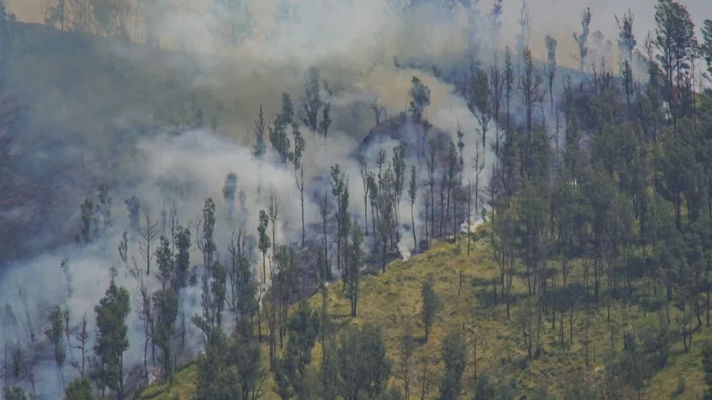
As plumes of thick, dark smoke billow into the azure skies over Bukit Pengol in Probolinggo Regency, authorities have confirmed that at least 10 distinct hotspots have been detected. The fast-moving flames are reportedly being driven by dry conditions and winds, pushing dangerously close to one of the national park’s most iconic and ecologically sensitive zones: the Lembah Watangan, widely known to travelers as the picturesque Bukit Teletubbies (Teletubbies Hill).
In response to the escalating crisis, the Balai Besar (Great Hall/Management Office) of TNBTS took swift precautionary measures, announcing the temporary closure of the popular Mount Bromo tourist access route via the Jemplang entrance in Malang.

Main Facts
The ongoing environmental emergency at TNBTS involves several critical developments that have disrupted travel itineraries and mobilized emergency response teams across East Java:
- Location of Incidents: The primary fires have concentrated around Bukit Pengol within the Probolinggo Regency section of the TNBTS, with active spread threatening the Lembah Watangan (Bukit Teletubbies).
- Hotspot Intensity: Monitoring teams have identified a minimum of 10 active hotspots across the affected terrain, complicating ground-level suppression efforts due to the rugged and undulating topography of the national park.
- Access Restrictions: The vital tourism and transit gateway at Jemplang, Malang, has been officially closed to incoming visitors since Thursday, September 10, 2026.
- Preemptive Policy Changes: Prior to the current outbreak, the management office had already suspended commercial and non-commercial photography and videography permits, as well as event-hosting permissions inside the conservation area, as an early risk-mitigation strategy.
- Partial Operational Continuity: Despite the partial lockdown, park management has clarified that general tourism activities in other designated zones of Mount Bromo and the tranquil Ranu Regulo area remain open and operational as usual.
Chronology of the Disaster
The sequence of events leading up to the current partial closure highlights the rapid escalation of the threat and the proactive steps taken by park rangers and emergency responders.
The Buildup and Early Precautionary Measures
Even before the first major columns of smoke became visible on Friday, September 11, 2026, authorities at the Balai Besar TNBTS were on high alert. Recognizing the heightened risk of dry-season fires—a recurring seasonal hazard in the region—management instituted a sweeping ban on commercial and non-commercial filming permits and large gatherings. This measure aimed to minimize human activity, vehicle traffic, and potential ignition sources deep within the fragile ecosystem.

The Outbreak and Hotspot Detection
Despite preventative measures, dry vegetation and unfavorable meteorological conditions triggered outbreaks across the terrain. By Friday, September 11, thick palls of smoke were seen rising dramatically over Bukit Pengol in Probolinggo. Aerial and ground monitoring subsequently confirmed at least 10 active hotspots. With unpredictable winds blowing across the savanna, the flames began to track menacingly toward the rolling green contours of the Lembah Watangan (Bukit Teletubbies).
Emergency Closure Implementation
Recognizing that public safety was paramount and that heavy tourist traffic would hinder firefighting logistics, the Balai Besar TNBTS enacted an immediate lockdown of the Jemplang entrance in Malang starting Thursday, September 10, 2026. This choke point serves as one of the primary arteries connecting Malang to the core Caldera of Bromo. Closing it effectively severed the southern approach, allowing firefighters, water trucks, and emergency personnel unhindered access to the front lines of the blaze.
Supporting Data and Environmental Context
The Bromo Tengger Semeru National Park is not merely a premier international tourist destination; it is a complex, high-altitude conservation area spanning across four administrative regencies: Probolinggo, Pasuruan, Lumajang, and Malang.

- Ecological Vulnerability: The park features a unique mix of montane forests, sub-alpine grasslands, and extensive savanna ecosystems (such as the Sea of Sand and Bukit Teletubbies). During the peak of the dry season—typically running from August through October—these grasslands transform into tinderboxes. Low humidity, parched vegetation, and strong winds create a volatile environment where a single stray spark can escalate into a massive wildfire within hours.
- Historical Precedents: Wildfires are an agonizingly familiar narrative for TNBTS. In previous years, severe dry-season fires have scorched hundreds of hectares of precious savanna and endemic flora, resulting in massive economic losses for local jeep drivers, homestay owners, and regional tourism boards, alongside long-term damage to the local fauna habitat.
- Infrastructure and Accessibility: The park’s topography makes firefighting exceptionally challenging. While paved and semi-paved roads accommodate tourists, much of the fire-affected terrain—such as steep ridges and deep valleys—can only be reached on foot by personnel carrying backpack pumps and hand tools, supplemented occasionally by water-dropping strategies if aerial units are deployed.
Official Responses and Stakeholder Actions
The management of TNBTS, alongside local disaster mitigation agencies (BPBD), forestry police, and community volunteers (such as Masyarakat Peduli Api or MPAs), has mobilized a multi-tiered response to contain the disaster.
Statement from Balai Besar TNBTS
In official statements released following the emergence of the 10 hotspots, park authorities emphasized that visitor safety and habitat preservation take absolute precedence over tourism revenue.
"The decision to temporarily close the Jemplang entrance was not made lightly, but it is a necessary intervention," a park spokesperson noted. "Our primary focus right now is to deploy personnel to strategic fire lines, prevent the blaze from completely ravaging the Bukit Teletubbies ecosystem, and ensure no tourists or unauthorized personnel are trapped within the danger zones."

Management of Unaffected Zones
To cushion the blow to the regional tourism economy, the administration has been careful to communicate that the entire national park is not entirely shut down. Visitors planning trips to specific sectors—such as the sunrise viewpoints overlooking the majestic Bromo crater or the serene lakeside settings of Ranu Regulo—can still proceed with their itineraries, provided they adhere strictly to updated safety guidelines, check local weather updates, and follow instructions from rangers on the ground.
Collaboration with Local Communities
Local jeep driver associations, horse rental cooperatives, and homestay owners in regions like Malang, Probolinggo, and Tumpang have also stepped up. Many local tourism workers, whose livelihoods depend directly on the health of the park, have volunteered their local geographical expertise to guide firefighters through complex terrain and assist in establishing firebreaks to halt the westward spread of the flames.
Implications for Tourism and the Local Economy
The timing of the fire deals a significant psychological and logistical blow to the East Java tourism sector, which relies heavily on steady weekend foot traffic.

Economic Fallout for Local Operators
The closure of the Jemplang access point directly impacts thousands of local residents who rely on the daily influx of travelers. Jeep drivers based in Tumpang and Malang who ferry tourists across the rugged terrain to witness the sunrise at Penanjakan or explore the Sea of Sand now face disrupted schedules and canceled bookings. Similarly, local culinary vendors, souvenir sellers, and lodging providers near the southern approach are experiencing an abrupt dip in revenue.
Long-Term Ecological Concerns
Beyond the immediate economic losses, environmental scientists and conservationists have expressed deep concern over the long-term ecological degradation caused by recurring fires. The destruction of endemic flora and the disruption of nesting grounds for local wildlife species can take years to recover naturally. Furthermore, severe fires strip the soil of its organic binding agents, increasing the risk of severe soil erosion, mudslides, and flash floods when the upcoming rainy season arrives.
Recommendations for Travelers
For international and domestic tourists planning a journey to Mount Bromo in the wake of this incident, authorities urge the following precautions:

- Verify Itineraries: Always check with official TNBTS social media channels or accredited tour operators before departing to confirm which gates and viewing areas are open.
- Respect Closures: Strictly avoid attempting to bypass barriers or enter closed sectors like Jemplang and Bukit Teletubbies. Doing so not only risks personal safety but also obstructs active firefighting operations.
- Support Open Zones: Consider supporting local communities by visiting unaffected areas like Ranu Regulo or coordinating with operators who utilize open northern and eastern approaches from Probolinggo or Pasuruan, while maintaining high vigilance regarding fire safety and discarding no cigarette butts or flammable materials.
As firefighting teams continue their relentless battle against the elements on the slopes of Bukit Pengol, the resilience of both the local community and the Bromo ecosystem faces yet another critical test. Authorities remain on high alert, hoping for favorable weather shifts and a swift, decisive end to the fires threatening one of Indonesia’s crown jewels.