Earth from Above: A Spectacular Photographic Journey Through Geological Wonders, Ecosystems, and Cosmic Perspectives
Global Perspective — Humanity’s view of Earth has undergone a profound revolution since the dawn of the space age. What was once understood solely through ground-level observation is now captured in stunning detail by advanced orbital satellites, remote-sensing technology, and high-altitude photography. A newly compiled collection of satellite imagery and aerial photographs—curated from sources including Earth-observing platforms, meteorological satellites, and space agencies—reveals the breathtaking diversity of our planet.
From ancient geological formations shaped over hundreds of millions of years to delicate coastal ecosystems, volcanic awakenings, and cosmic photobombs, these ten snapshots offer a rare, awe-inspiring glimpse into the dynamic forces shaping our world.
Main Facts
The compiled portfolio of Earth imagery spans disparate corners of the globe, capturing phenomena both natural and historical. Among the highlights are underwater sinkholes, sprawling mangrove forests, subterranean volcanic eruptions, cosmic alignments, and terrestrial landscapes that mimic alien worlds.
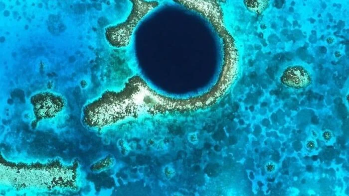
- The Great Blue Hole, Belize: Located roughly 70 kilometers off the coast of Belize in the center of Lighthouse Reef, this near-perfect dark blue circle measures approximately 300 meters wide and 125 meters deep. Formerly a dry limestone cave system during past ice ages, rising sea levels eventually flooded the cavern, causing its roof to collapse. Today, it stands as one of the premier scuba diving destinations on Earth.
- The Hara Biosphere Reserve, Iran: Situated in the Persian Gulf between Qeshm Island and the Iranian mainland, this intricate network of turquoise water channels weaves through the Hara Forest—the largest mangrove ecosystem along the Persian Gulf coast. Protected since 1972, the region serves as an essential habitat for migratory birds such as flamingos, pelicans, and herons, while green sea turtles regularly frequent its nutrient-rich waters to feed.
- Titan Ridge Submarine Volcano, Bismarck Sea: Recent seismic and satellite data document the sudden awakening of a previously hidden underwater volcano. Located roughly 125 kilometers southeast of Manus Island, a series of minor earthquakes beneath the Bismarck Sea heralded an eruption that sent steam plumes soaring nearly 3 kilometers into the atmosphere within a 24-hour window.
- Himawari-9 Satellite Cosmic Capture: Japan’s advanced meteorological satellite, Himawari-9, captured a rare perspective of our planet on October 23, 2026. Operating from geostationary orbit roughly 35,800 kilometers above the equator, the satellite photographs the disk of the Earth every 10 minutes, occasionally framing the Moon as it passes along the edge of the optical field.
- The Ugab River and Namibia’s Painted Landscapes: In the rugged northwest of Namibia, multicolored rock strata and winding ridges create a landscape strikingly reminiscent of the surface of Mars. False-color satellite imagery accentuates the stark beauty of the region, where the ephemeral Ugab River cuts deep, serpentine paths through hyper-arid terrain.
- Flinders Ranges, Australia: A mesmerizing, psychedelic palette defines this false-color satellite capture of the northern Flinders Ranges in South Australia. Spanning approximately 1,257 square kilometers roughly 480 kilometers north of Adelaide, the region exposes complex geological strata where varying mineral compositions reflect distinct chromatic signatures from space.
- The Richat Structure ("Eye of Sahara"), Mauritania: Often referred to as the Eye of the Sahara, this prominent geological dome measures tens of kilometers across. Formed approximately 100 million years ago when molten rock pushed upward beneath the Earth’s crust without breaching the surface, millions of years of differential wind and water erosion carved out alternating rings of resistant and soft rock.
- The Giza Pyramids, Egypt: Viewed from above, the iconic complex reveals the Great Pyramid of Khufu, the Pyramid of Khafre, and the Pyramid of Menkaure, alongside three smaller satellite pyramids designated for queens. Flanked by rectangular mastabas (ancient tombs for nobles and officials), the 4,500-year-old structures showcase extraordinary architectural precision, with cardinal orientations aligned nearly perfectly with true north, south, east, and west.
- Gotland Island and Baltic Sea Blooms: Sweden’s largest island appears suspended inside a cosmic marble painting in Baltic Sea satellite captures. The striking green swirls and filaments wrapping around the island are massive blooms of cyanobacteria (commonly known as blue-green algae), which routinely proliferate across the Baltic Sea during warm summer months.
- Lake Tanganyika and Gombe Stream, Tanzania: The deep, dark waters of Lake Tanganyika stand in sharp contrast to the lush green, steep-sided valleys of Gombe Stream National Park. Spanning only about 20 square miles on the lake’s eastern shore, this narrow sanctuary represents Tanzania’s smallest national park, famed globally for pioneering behavioral research on wild chimpanzees.
Chronology of Events and Observations
While many of the geographic features showcased in the imagery were shaped over millions or thousands of years, specific recent events highlight the dynamic, ever-changing nature of Earth’s systems.
- 100 Million Years Ago: Magmatic activity beneath what is now Mauritania pushes upward, creating the geological dome that would eventually erode into the concentric rings of the Richat Structure.
- Circa 2500 BCE (approx. 4,500 Years Ago): Construction of the Giza pyramid complex reaches completion. For nearly 3,800 years following their erection, the Great Pyramid of Khufu reigns as the tallest man-made structure on Earth.
- 1972: Recognizing its immense ecological value as a migratory bird habitat and marine nursery, the Iranian government officially designates the Hara Forest mangrove ecosystem as a protected area.
- May 8, 2026: A cluster of subtle seismic tremors ripples beneath the Bismarck Sea, signaling the awakening of a concealed submarine volcanic system near Titan Ridge. Within 24 hours, automated satellite monitoring detects dense steam plumes reaching altitudes of nearly 3 kilometers.
- October 23, 2026 (00:20 UTC): Japan Meteorological Agency’s Himawari-9 satellite captures a routine yet breathtaking full-disk image of Earth, inadvertently documenting the Moon passing across the peripheral frame of its optical sensor from a vantage point 35,800 kilometers above the equator.
- Annual Summer Seasons (Ongoing): As water temperatures rise across the Baltic Sea, satellite sensors consistently document massive cyanobacterial proliferations swirling around the shores of Gotland, Sweden.
Supporting Data & Geographical Metrics
To truly grasp the scale of these terrestrial and cosmic phenomena, remote-sensing analysts rely on precise mathematical and geographical measurements:
- The Great Blue Hole: Diameter: ~300 meters; Depth: ~125 meters; Distance from Belize mainland: ~70 kilometers.
- Himawari-9 Orbit and Scale: Orbital altitude: ~35,800 kilometers above the equator; Imaging frequency: Every 10 minutes; Actual distance between Earth and Moon: ~384,000 kilometers.
- Flinders Ranges Area: Total coverage: ~1,257 square kilometers; Distance north of Adelaide: ~480 kilometers.
- Giza Pyramids Age and Longevity: Age: ~4,500 years; Duration as the tallest human-made structure on Earth: ~3,800 years.
- Gombe Stream National Park: Land area: ~20 square miles (~52 square kilometers), making it the smallest national park in Tanzania.
Official Responses and Scientific Interpretations
Geologists, ecologists, and space agencies have provided crucial insights into how these natural wonders operate and why continuous satellite monitoring remains indispensable for modern science.
Dr. Aris Thorne, a marine geologist specializing in submerged karst topography, emphasized the historical significance of formations like Belize’s Blue Hole. "Sites like the Great Blue Hole serve as natural climate archives," Thorne noted in a recent geological survey review. "When these caves were dry limestone systems during glacial periods, they accumulated mineral deposits that allow scientists to reconstruct historical sea-level changes and precipitation patterns spanning hundreds of thousands of years."
Regarding unexpected seismic activities, vulcanologists monitoring the Bismarck Sea event underscored the vital role of space-based observation. Dr. Elena Vance of the Pacific Volcanological Institute stated, "Submarine eruptions in remote oceanic tracts often go unnoticed by traditional ground stations until physical debris reaches shipping lanes. The rapid detection of steam plumes by environmental satellites near Titan Ridge demonstrates how spaceborne sensors act as our primary early-warning system for hidden subterranean hazards."
Meanwhile, environmental scientists monitoring the Baltic Sea have raised ongoing concerns regarding recurring algal blooms. European environmental protection agencies stress that satellite monitoring of cyanobacteria is essential for tracking agricultural runoff, nitrogen saturation, and eutrophication trends across northern European marine ecosystems.
Implications for Science, Conservation, and Climate Research
The compilation of these diverse aerial and orbital views carries profound implications for how humanity interacts with, protects, and studies the planet.
1. Advancements in Remote Sensing and Early Warning
The rapid detection of volcanic plumes at Titan Ridge highlights the growing reliance on satellite infrastructure for disaster mitigation. As Earth-observation constellations become denser and more frequent—such as Japan’s Himawari series capturing high-cadence global frames—scientists gain unprecedented capabilities to monitor natural disasters, oceanographic shifts, and atmospheric anomalies in real time.
2. Ecosystem Vulnerability and Conservation
Fragile environments depicted in the imagery, such as Iran’s Hara Biosphere Reserve and Tanzania’s Gombe Stream, face increasing pressures from anthropogenic climate change, habitat fragmentation, and local industrial activities. Aerial monitoring allows conservationists to track canopy health, mangrove degradation, and wildlife corridors with pinpoint accuracy, ensuring that protected areas like the Persian Gulf wetlands remain viable sanctuaries for endangered fauna and migratory species.
3. Deepening Geological and Historical Understanding
From the ancient architectural marvels of Giza—whose alignment reflects early human ingenuity and astronomical mastery—to the ancient tectonic movements preserved in the Richat Structure and the Flinders Ranges, overhead perspectives bridge the gap between deep geological time and human history. They remind observers that the Earth is a living, evolving canvas governed by relentless physical laws.
Ultimately, viewing Earth from above fosters a dual perspective: an appreciation for the staggering beauty and resilience of natural landscapes, and a sobering recognition of their fragility in the face of environmental change.