Moderate Magnitude 5.5 Earthquake Strikes Sunda Strait; No Tsunami Threat Detected, Authorities Urge Calm
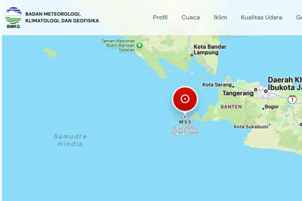
JAKARTA — A moderate-intensity earthquake measuring magnitude 5.5 struck the Sunda Strait region in the early hours of Wednesday, sending tremors across parts of Banten and West Java provinces. According to the Meteorology, Climatology, and Geophysics Agency (BMKG), the seismic event occurred at a depth of 43 kilometers and did not trigger a tsunami.
While the tectonic activity caused momentary panic among coastal residents still mindful of the region’s volatile history, disaster management officials confirmed that the structural integrity of local infrastructure remained largely intact. The agency has urged the public to rely on verified channels for information as field teams conduct rapid damage assessments in the most affected districts.
Chronology of the Event
The seismic event occurred during the quiet, pre-dawn hours of Wednesday, catching many sleeping residents by surprise.
- 02:45 AM WIB (Western Indonesian Time): Deep-sea tectonic stresses along the subduction interface in the Sunda Strait reached a critical threshold, triggering a sudden rupture. Seismic waves radiated outward from the hypocenter.
- 02:46 AM WIB: BMKG’s automated Early Warning System (InaTEWS) registered the primary and secondary waves across multiple seismic stations in western Java and southern Sumatra. Initial automated readings were processed to determine the preliminary magnitude and epicenter.
- 02:50 AM WIB: BMKG issued its first official bulletin to the public, media, and disaster management agencies. The report characterized the event as a magnitude 5.5 earthquake, pinpointing the epicenter in the waters of the Sunda Strait, approximately 62 kilometers southwest of Sumur, Pandeglang Regency, Banten. Crucially, the agency’s automated modeling systems indicated that the earthquake’s physical characteristics—specifically its depth and magnitude—were insufficient to displace the water column required to generate a tsunami.
- 03:05 AM WIB: Following a standard 15-minute observation window, BMKG’s Earthquake and Tsunami Center reported that its regional monitoring networks had detected no aftershocks.
- 03:30 AM WIB: Local disaster management agencies (BPBD) in Pandeglang, Lebak, and Sukabumi mobilized rapid response units to assess structural damage, particularly in vulnerable coastal settlements nearest to the epicenter.
Seismological Analysis and Supporting Data
The Sunda Strait is one of the most complex and hazardous tectonic zones on Earth, serving as a transition zone between the oblique subduction of the Indo-Australian Plate beneath the Eurasian Plate (specifically the Sunda Block) along the Java Trench.
       TECTONIC PROFILE: SUNDA STRAIT SUBDUCTION ZONE

             [ North / Sunda Block / Eurasian Plate ]
                             ^
                             | (Overriding Plate)
  ===========================+===========================
  [ Epicenter: 62km SW of Sumur ]   | (Depth: 43 km)
               *                    |
              /                    | [ Thrust Fault Mechanism ]
             /                     v
  =======================================================
     (Subducting Plate)  /
                        /
                       v
         [ Indo-Australian Plate ] (Subducting South-to-North)
The Tectonic Framework of the Sunda Strait
The earthquake’s epicenter was located at the geographic coordinates of 6.83° South Latitude and 105.04° East Longitude. This coordinate places the rupture point directly in the marine environment of the Sunda Strait, a critical maritime corridor separating the islands of Java and Sumatra.
In this region, the oceanic Indo-Australian Plate moves northward, plunging beneath the continental Sunda Plate at a rate of approximately 50 to 60 millimeters per year. This convergent boundary creates immense frictional resistance, accumulating stress over decades and centuries that is periodically released in the form of earthquakes.
Understanding Thrust Fault Mechanisms and Depth
According to Wijayanto, the Director of the Earthquake and Tsunami Center at BMKG, a rigorous analysis of the seismic wave source parameters revealed that the earthquake was characterized by a thrust fault mechanism (compression-driven upward movement).
"The focal mechanism analysis shows that this earthquake occurred as a direct result of subduction plate activity," Wijayanto explained in his technical briefing in Jakarta.
The hypocenter was determined to be at a depth of 43 kilometers. In seismological classification, this places the event in the shallow-to-intermediate category. Earthquakes occurring at this depth range typically produce widespread but moderate shaking.
Because the rupture occurred deep within the subducting lithospheric slab rather than close to the shallow seafloor interface, and because its magnitude remained at 5.5, the vertical displacement of the seabed was negligible, precluding any threat of a tsunami.
Intensity Assessment: The Modified Mercalli Intensity (MMI) Impact
The energy released by the thrust fault propagated through the crust, manifesting as perceptible shaking across several regencies in Banten and West Java. BMKG mapped these ground motions using the Modified Mercalli Intensity (MMI) scale:
| Location | Distance/Direction from Epicenter | MMI Scale | Perceived Shaking & Physical Effects |
|---|---|---|---|
| Sumur District, Pandeglang | ~62 km Northeast | IV MMI | Felt by many indoors, few outdoors. Pottery breaks, windows/doors creak, walls emit cracking sounds. |
| Pandeglang Regency (General) | ~70–90 km Northeast | III–IV MMI | Felt significantly indoors; hanging objects swing; vibration resembles a heavy truck passing nearby. |
| Bogor Regency, West Java | ~140 km East-Northeast | III MMI | Vibration felt clearly indoors, comparable to the passing of a heavy truck. |
| Lebak Regency, Banten | ~100 km East | III MMI | Light shaking felt by residents resting indoors; minor swinging of light fixtures. |
Official Responses and Public Safety Directives
Following the event, Indonesian administrative and scientific bodies mobilized to manage public safety and maintain order, focusing on structural assessments and combating misinformation.
BMKG’s Scientific Assurance and Public Warnings
BMKG Director Wijayanto emphasized the importance of scientific literacy during the aftermath of marine seismic events. He reiterated that while the Sunda Strait is historically capable of generating tsunamis—such as the devastating volcanogenic tsunami of 2018—the structural parameters of this specific event offered no physical mechanism for ocean wave propagation.
"We urge the public in coastal Banten and western Java to remain calm," Wijayanto stated. "Our monitoring systems are running continuously. The modeling we performed immediately after the event confirmed that there is absolutely no tsunami potential. Residents do not need to evacuate to higher ground, but they must remain vigilant against local structural hazards."
Regional Disaster Mitigation Agency (BPBD) Field Operations
In Pandeglang Regency, the local BPBD dispatched emergency response units to coastal sub-districts, including Sumur, Cimanggu, and Cibaliung. Sumur, being closest to the epicenter, received the highest priority for rapid damage assessments.
Emergency responders conducted street-level inspections of residential structures, schools, and medical clinics. Early reports from village heads indicated that while the shaking caused brief panic—prompting families to run out of their homes into the night—there were no immediate reports of casualties, severe injuries, or collapsed buildings.
Mitigating Misinformation and Digital Panic
A major challenge identified by authorities was the rapid spread of unverified rumors on social media platforms. Within minutes of the earthquake, speculative posts regarding potential volcanic activity from Anak Krakatau and false warnings of incoming waves began circulating in local message groups.
In response, BMKG and the Ministry of Communication and Information Technology (Kominfo) issued joint advisories warning the public against sharing unsourced advisories.
"Do not be influenced by issues that cannot be scientifically accounted for," Wijayanto warned. "All official updates will be disseminated through our verified channels, including the ‘InfoBMKG’ mobile application, official social media handles, and direct coordination with local BPBD offices."
Broader Implications: Tectonic Anxiety and Disaster Preparedness
While the magnitude 5.5 earthquake did not result in a disaster, it serves as a stark reminder of the chronic tectonic vulnerabilities facing the western coast of Java.
                  SUNDA STRAIT SEISMIC HAZARD FACTORS

   +---------------------------------------------------------------+
   |                      SUNDA STRAIT REGION                      |
   +---------------------------------------------------------------+
            |                                       |
            v                                       v
+-----------------------+               +-----------------------+
|  Tectonic Megathrust  |               | Volcanic Hazards      |
|  * Indo-Australian /  |               | * Anak Krakatau       |
|    Sunda Plate        |               |   Activity            |
|  * M8.7 Potential     |               | * Volcanogenic        |
|  * Historic Ruptures  |               |   Tsunami Risks       |
+-----------------------+               +-----------------------+
            |                                       |
            +-------------------+-------------------+
                                |
                                v
                +-------------------------------+
                |     Mitigation Priorities     |
                |  * Retrofitting Structures    |
                |  * Community Drills           |
                |  * Early Warning Upgrades     |
                +-------------------------------+
The Shadow of the Sunda Strait Megathrust
The Sunda Strait is home to the "Sunda Strait Megathrust Segment," a seismic gap that seismologists believe is capable of generating a megathrust earthquake of magnitude 8.7 or higher. Because this segment has not experienced a major, full-rupture earthquake in centuries, it has accumulated a massive deficit of seismic slip.
Consequently, even moderate earthquakes like the one on Wednesday trigger high levels of anxiety among local populations and disaster management planners. Seismologists view these moderate events as critical data points, helping them map stress distribution along the subduction plate interface and refine predictive hazard models for the region.
Improving Rural Infrastructure Resilience
The concentration of MMI IV intensity in Sumur highlights the ongoing challenge of rural infrastructure resilience in Indonesia. In many parts of Pandeglang and Lebak, residential homes are built without seismic-resistant engineering, utilizing unreinforced masonry that is highly susceptible to cracking during moderate ground acceleration.
Disaster mitigation experts emphasize that preventing casualties in future, larger earthquakes depends heavily on retrofitting existing structures and enforcing strict building codes for new constructions.
BMKG has urged residents returning to their homes to carefully inspect walls, load-bearing pillars, and roofs for structural compromises. Buildings that suffered minor cracking during this event are at a significantly higher risk of failure should a larger aftershock or a separate seismic event occur in the near future.
Enhancing Community-Level Readiness
The quick response of the community in Sumur—where many immediately evacuated their homes upon feeling the initial tremors—demonstrates a high level of survival instinct, likely reinforced by memories of past disasters. However, authorities stress that self-evacuation must be guided by structured training rather than panic.
Through programs like the "Tsunami Ready Community" initiative, BMKG and local NGOs continue to work with coastal villages to establish clear evacuation routes, install solar-powered siren towers, and conduct regular evacuation drills. Keeping these systems active and maintaining community readiness remains the most effective defense against the inevitable tectonic shifts of the Sunda Strait.