The Global Pulse of the Southern Ocean: How Antarctic Storms Shape the World’s Coasts
When a surfer carves a wave at the world-renowned breaks of Mentawai or watches the rollers crash against the rugged cliffs of Pacitan in Java, they are participating in a global energy transfer that began thousands of miles away. While these waves appear to be local phenomena—products of immediate coastal weather—the reality is far more profound. Many of the swells that grace the shores of Indonesia are, in fact, the final, spent remnants of massive storm systems that raged days earlier in the icy, turbulent waters surrounding Antarctica.
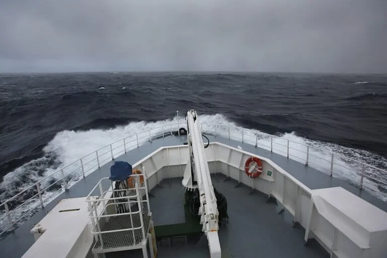
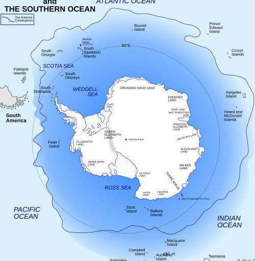
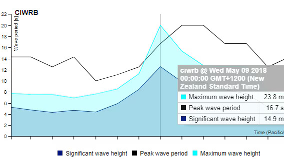
The Southern Ocean, a vast, unbroken ring of water encircling the frozen continent, acts as the planet’s primary engine for oceanic energy. In May 2018, a MetOcean Solutions buoy anchored near Campbell Island, roughly 700 kilometers south of New Zealand, captured a wave measuring 23.8 meters (78 feet) in height. While this stands as one of the most significant measurements in the Southern Hemisphere, it serves as a stark reminder that the ocean’s behavior in these remote, high-latitude regions dictates the rhythm of the global shoreline.
The Roaring Engine: Why the Southern Ocean Dominates
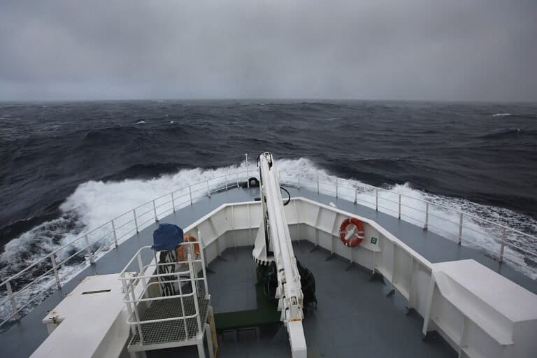
The primary reason the Southern Ocean is a factory for the world’s most powerful swells lies in its unique geography. Between the latitudes of 40 and 60 degrees south, the Earth is essentially an open water track. Unlike the Northern Hemisphere, where massive continental landmasses like North America and Eurasia interrupt the flow of wind and weather, the Southern Ocean provides an unobstructed path for the "Westerlies."
Sailors have long identified these regions by their ferocious reputation: the Roaring Forties, the Furious Fifties, and the Screaming Sixties. Because there is almost no land to create friction or deflect wind, storms in this region can travel in a continuous loop around the globe. When wind blows consistently over long distances—a phenomenon oceanographers call "fetch"—it transfers kinetic energy into the water. In the Southern Ocean, the three requirements for massive waves are met with terrifying efficiency: strong, sustained winds, a vast fetch, and a storm path that moves in tandem with the waves it creates. This synchronicity allows waves to grow continuously as the storm tracks eastward, resulting in long-period, highly energetic swells.
Chronology of a Giant: The 2018 Campbell Island Event
The event in May 2018 provides a case study in oceanic extreme weather. As the storm system tracked across the Southern Ocean, meteorologists and oceanographers observed a rare alignment of variables. The speed of the storm front was roughly equal to the phase velocity of the waves. This meant that as the storm moved, it remained "locked" over the waves it was generating, pumping energy into them for a prolonged period.
The data captured by the MetOcean Solutions buoy was definitive. At the peak of the storm, the buoy registered a single individual wave of 23.8 meters. To put this in perspective, that is roughly the height of an eight-story building. This measurement, while not a world record, confirmed the sheer destructive potential of the Southern Ocean’s winter storms.
Following the peak, the energy did not simply vanish. Once the waves moved out from under the influence of the storm’s gale-force winds, they transitioned into "swells." These swells are remarkably resilient; they can travel thousands of miles across the Pacific and Indian Oceans, losing only a fraction of their energy along the way. Historical data from the 1960s famously tracked swells generated in the Southern Ocean all the way to the coast of Alaska—a journey of nearly half the circumference of the Earth.
Supporting Data and the Science of Measurement
To understand these monsters, scientists differentiate between two key metrics: Individual Wave Height and Significant Wave Height.
- Individual Wave Height: This is the measurement of a single, solitary crest in a recorded series. It represents the "freak" or "rogue" element of a sea state.
- Significant Wave Height: This is the average height of the highest one-third of waves in a given period. It is the gold standard used by the World Meteorological Organization (WMO) to describe the "state" of the sea.
During the 2018 event, while the individual wave hit 23.8 meters, the significant wave height was 14.9 meters. This distinction is crucial for maritime safety. A captain might look at a significant wave height report and feel safe, only to be struck by an individual "rogue" wave that far exceeds the average.
When comparing these figures to global records, the North Atlantic currently holds the title for the largest verified measurements. In February 2013, a buoy between Iceland and the United Kingdom recorded a significant wave height of 19 meters. For individual waves, the research vessel RRS Discovery recorded an estimated 29-meter wave in the Rockall Trough (North Atlantic) in February 2000. However, many oceanographers argue that the Southern Ocean remains vastly under-monitored. Because of its remoteness, it is highly probable that even larger waves have occurred in the Southern Ocean without ever being recorded by a buoy or witnessed by a ship.
Implications: Climate, Ecology, and Global Connectivity
The impact of these waves extends far beyond the excitement of the surfing community or the challenges of maritime navigation; they are a fundamental component of the Earth’s climate system. When waves of this magnitude break, they act as massive mixers, churning the upper layers of the ocean. This process facilitates the exchange of heat and gases—most notably carbon dioxide—between the atmosphere and the deep ocean.
The Southern Ocean is a primary "sink" for the world’s anthropogenic heat and CO2 emissions. By mixing these elements into the depths, the ocean helps regulate the global climate. Consequently, any shift in the frequency or intensity of Southern Ocean storms has immediate implications for global warming trends.
Furthermore, the ecosystem of the Southern Ocean has evolved in lockstep with these harsh conditions. The Wandering Albatross (Diomedea exulans), an iconic seabird with a wingspan exceeding three meters, is a master of this environment. These birds utilize "dynamic soaring," a technique that exploits the wind gradient—the difference in wind speed near the surface of a wave compared to higher altitudes—to travel thousands of kilometers with minimal caloric expenditure. They are essentially biological satellites, relying on the same meteorological engine that powers the swells hitting the Indonesian coast.
The Need for Future Observation
Despite the technological advancements of the 21st century, our understanding of the Southern Ocean remains fragmented. The 2018 buoy data was a breakthrough, but it represented only a tiny pinprick in a massive, chaotic expanse.
Official responses from organizations like the WMO emphasize that the lack of continuous, high-resolution data from the Southern Ocean is a significant gap in climate modeling. As satellite technology improves and autonomous, solar-powered buoys become more common, scientists hope to create a more robust network of sensors.
For the residents of coastal regions in Indonesia, India, and even the Western United States, this research is not merely academic. It is vital for coastal planning. As climate change alters wind patterns and storm tracks, the intensity and frequency of these long-distance swells may change. Being able to predict when a "groundswell" from an Antarctic storm will arrive allows for better disaster mitigation, safer fishing practices, and a deeper appreciation of the invisible, interconnected threads that link the frozen southern pole to the tropical shores of the equator.
The next time a massive, clean set rolls into a beach in Indonesia, remember: that water is not just a local event. It is a messenger from the bottom of the world, carrying the memory of a storm that shook the Southern Ocean days before.